| |
|
Projects
Some projects to which Tamanes Software contributed in the years 2000, for
Fugro-Inpark B.V. and Fugro Aerial Mapping B.V. Click at a titlebar to open.
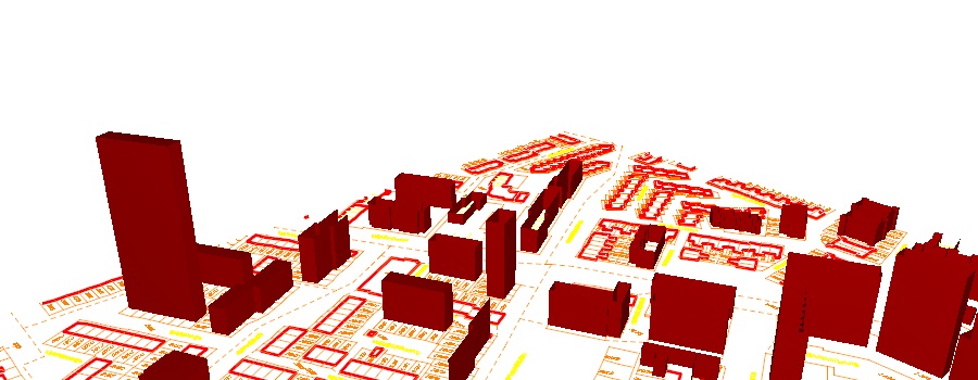
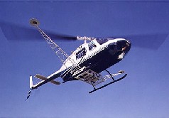
FLI-MAP

Tamanes Software contributed many times to the development of
software for FLI-MAP, a registered trademark of
John Chance Land Surveys, Inc.
FLI-MAP projects in Europe, Africa, Asia and Australia are executed by
Fugro Aerial Mapping B.V.
FLI-MAP ® (Fast Laser Imaging and Mapping Airborne Platform)
is a laser altimetry system using a laser scanner from a helicopter,
measuring points on the ground. The laser scanner shoots pulses with a
frequency (from 100,000 to 250,000 measurements per second) pulses, the width of
the scan being equal to the altitude of the helicopter (up to about 1000m).
Through deflection using a rotating mirror, laser pulses hit the
site in a line perpendicular to the direction of the flight. The energy of the
laser pulses is absorbed and partly reflected by the ground or some object in the field.
The reflected part of the pulse is captured by a sensor next to the laser.
The time difference between the moment when a pulse is transmitted and the moment
when the reflection is detected is a measure of the
distance from the helicopter to the ground or the object. Because the
position and state of the helicopter at the moment
when the pulse was broadcasted is known accurately in space,
and also the direction towards emission, the coordinates of
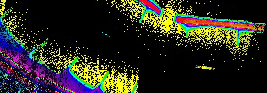
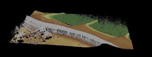
the point beneath can be calculated. The result is a density
of about 20 to 100 measurements per m². With this density of the X, Y and Z
coordinates, a very accurate model of the terrain and
objects in the field can be obtained, and lots of data can
be derived from it.
The speed of data acquisition and accuracy of FLI-MAP ®
makes the system suitable for, among others, these applications:
- Power lines
- Railways
- Pipeline route measurements
- Topography (DTM) measurements
- Telecommunications trace measurements
- Dikes and levees
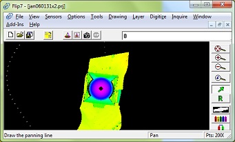 Software
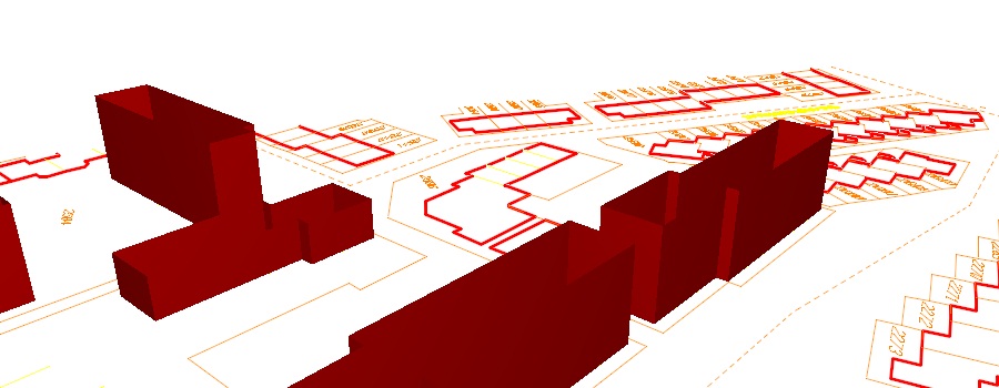
Tamanes Software has contributed to various parts
of the program Flip7. This program is used to elaborate the great
amount of data obtained in a FLI-MAP
project. The program combines the presentation of the millions of measured laserpoints
on screen with a complete CAD system. From the positions of the helicopter,
obtained by GPS, and transformed
according to the relevant cartographic transformation,
it calculates the XYZ positions of the laser points.
In addition, a Flip7-operator disposes of photo and video images, captured during the flight.
With all these resources, the data can be dispatched fast and efficiently.
The so-called filters offer an extremely flexible option
to process the measured laser points.
A customer can write or let write an own filter, a
pluggable piece of program into Flip7,
by which the laserpoints and their colors are displayed according to whatever principle,
in order to easily distinguish the relevant data from the irrelevant.
Exchange of data of the measured laser points is often done with files in the
binary exchange format LAS (Laser File Format), as defined by the ASPRS
(American Society of Photogrammetry and Remote Sensing).
Here again Tamanes Software contributed to create the necessary software.
Flip7 en NG
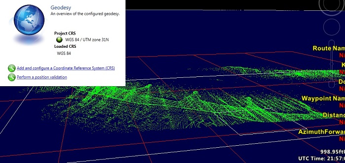
In time, the FLI-MAP data will not be processed with Flip7 any more, but with
Starfix-NG, a new Fugro-project that is used and will be used for many other
GPS-based purposes as well.
This exciting program is currently in plain development.
Infra
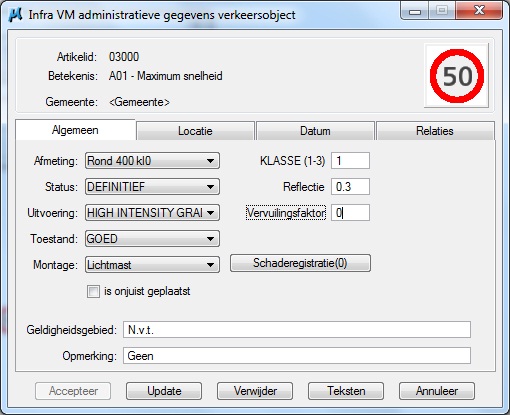
Infra is a user-friendly application for design and drafting of civil works, and was
developed by
Fugro-Inpark B.V.
Tamanes Software is a contributor to the development and maintainance of the programs.
The application, in Dutch language and for use within Bentley's MicroStation, contains a large amount
of civil engineering definitions and symbols, but can, by means of tables, be adapted
to specific needs of users. Infra includes the following modules:
- Topography (design of topographic features)
- Cables & Pipes (design of cables and pipelines)
- Drainage (design and maintenance of sewers and wells)
- Green (design of elements for landscaping)
- Roads (design of road elements)
- Drivecurve (graphic module for simulating the behavior of vehicles
in curves, in conjunction with the program CURSIM of
Goudappel Coffeng B.V.)
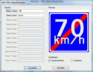
- Traffic Signs (module for graphic and administrative management of
especially traffic signs, but also crosswalks, road markings,
parking meters, etc., connected with
Oracle, Access or SQL Server database).
- File Checker (module to check whether all elements in a drawing satisfy criteria).
- InfBudgets (automatic preparation of specifications from a drawing, based on lengths,
areas and quantities, and the layers of elements, and according
to the Dutch standard format RSU)
- NLCS (module for producing drawings according to the
in the Netherlands increasingly used definitions
"Dutch civil engineering CAD Standard for the GWW").
Infra furthermore includes a number of "Tools", convenient features, including:
- Photo Viewer (for linking photograph references to MicroStation
elements, and for viewing these pictures)
- Legend Maker (to automatically produce a legend of all
elements in a drawing, or a selection of them)
- Object Changer (for changing properties such as Product, Scale,
etc. of all elements in a drawing, or a selection of them).
Infra furthermore includes:
- Traffic Decisions (to manage Traffic Decisions in a City Community
using an Oracle, Access or SQL Server database; not for use within
Bentley's MicroStation, but can cooperate with the Traffic Signs module).
- FieldWork (for exporting and importing data from the module Transport Signs,
in order to update the data in the field, with a field computer with MicroStation
and Infra Traffic Signs installed).
Website Infra (Dutch): http://www.fugrociviel.nl/infra/
Inca
Tamanes Software has contributed to the development
of software for Inca. Inca is a management system for usage within Bentley's MicroStation,
for drawings with administrative data connected, in various ways.
By means of XML-based configuration, relatively quickly a management environment
for a new customer can be built.
Other
On behalf of
Fugro-Inpark B.V.
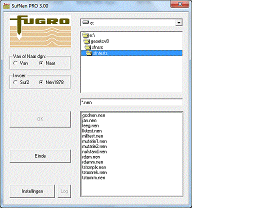
Tamanes Software has contributed to development of the following software:
- Conversion of files in Suf2 and Nen1878-format to and from Bentley's MicroStation.
- Elaboration of designfiles in Bentley's MicroStation with so-called fgu-userdata.
- Conversion of various 3D-exchange formats, for example for projects of "Rijkswaterstaat".
- Structuring designfiles Bentley MicroStation (connection of polygons and arcs
nearly connected, cuts, elimination of double elements, optimalizaciónes, aggregation
left-right information, training shapes of polygons, centroids).
|
|
|
|
|
|
|